Photogrammetry is a technique that extracts precise spatial data from photographs, allowing real-world objects and environments to be reconstructed digitally. By analyzing multiple images taken from different viewpoints, photogrammetry software identifies common features and calculates their position in three-dimensional space. The result is a detailed digital representation that preserves both geometry and visual appearance.
One of the key strengths of photogrammetry is its flexibility. Images can be captured using anything from professional DSLR cameras to smartphones and drones, making the technology accessible across many industries. In architecture and construction, photogrammetry is used to document sites, monitor progress, and generate accurate measurements without physical contact. In archaeology and cultural heritage, it enables the preservation of artifacts and historical locations in digital form, reducing the need for repeated handling or exposure to environmental damage.
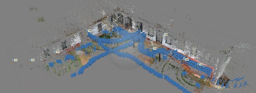
The technical workflow typically begins with image alignment. Software scans each photograph to detect distinctive points—edges, textures, and patterns—that appear in multiple images. These shared features are matched across the dataset to estimate camera positions and orientations. From this information, a sparse point cloud is created, which is later refined into a dense point cloud. This data is then converted into a polygonal mesh and enhanced with high-resolution textures derived from the original photos.
While photogrammetry excels at capturing surface detail and color, it has limitations. Highly reflective, transparent, or featureless surfaces can be difficult to reconstruct accurately. Lighting consistency and image overlap also play a significant role in the quality of the final model. For this reason, careful planning during image capture is just as important as the processing stage.
Despite these constraints, photogrammetry remains a cost-effective and scalable solution for 3D data acquisition. It is often used alongside other technologies, such as LiDAR or manual modeling, to balance accuracy and efficiency. As computing power increases and algorithms improve, photogrammetry continues to evolve into a reliable method for transforming visual information into structured, measurable digital assets.
Article test for category: Neutal